
Almost 67 miles south east of Oceanside , California Palomar Mountain ’s 6,140 foot peak and beneath the charred forest of Santa Ysabel Mountain , I wound my way on San Diego County ’s two lane back roads towards the tiny town of Ranchita Lake Henshaw Montezuma Valley Road Anza Borrego Desert and to the Salton Sea .

On a whim, local realtor Joe Rauh began creating the prototype for his eye catching sign holder, and he and his twin brother made their 2007 debut at the three day, nonstop, six stage Ranchita Rocks Music Festival, a fundraiser held annually at Carolyn Morrow’s Golightly Farm for the Protect our Communities Foundation, a nonprofit organization opposed to the San Diego Gas & Electric Company’s (SDGE) proposed Sunrise Powerlink. The yeti’s face, designed by special effects artist, Mark Alfrey, (Men in Black, Buffy the Vampire Slayer, and Planet of the Apes), has a sweet if not slightly stern expression that beckons you to stand between its feet and hold its hands, which of course I promptly did. Rauh, who takes custom orders, later created the Blues Brother inspired BB (Bell Bottoms) Blues—shades and guitar included-- and the blonde haired, blue-eyed surfer model he named Larry. I don’t know where Rauh keeps BB and Larry, but I’d like to see them along side Rancheti. Perhaps when I come back for the Music Festival, they too will be there to welcome me to San Diego County’s backcountry, and the desert and sea beyond.
Southern California’s Grid Controversy
For those who are not yet acquainted with the Sunrise Powerlink controversy, know that it is Sempra Energy Utility’s vision of building a 123 mile long transmission line that would begin in Mexico, span Imperial County, California and slice through pristine and protected San Diego County backcountry. By protected I mean Bureau of Land Management (BLM), U.S. Forest Service (USFS) acreage and the State’s Anza Borrego Desert Park all designated for preservation. The Borrego—for the record--is the largest State park in California and the second largest state park in the nation.

 Typically, not everyone is of the same opinion. The County, BML, USFS, and Governor’s Office, for instance, support the project. Former Governor Schwarzenegger, mind you, besides supporting this project closed 150 of the 278 State Parks that had been previously designated to protect approximately 1.5 million acres, 280 miles along the Pacific coast and 625 miles frontage on lakes and rivers. While the State’s Park System, the country’s largest, is reeling from huge budgetary cuts, few off highway vehicle (OHV) parks have been closed in an effort to curb expenditures, (although there are court ordered closures of OHV parks due to environmental infractions). No shock then to understand why park advocates and environmentalists questioned his motives altogether, at least as they pertained to land and wildlife preservation. And is it me, or does the placement of high voltage transmission lines along the San Andreas Fault
I, myself, am at a loss as I, too, had thought the purpose of park systems was to actually preserve nature in perpetuity for passive public enjoyment. Needless to say, I don’t make the rules and on September 16, 2010 the State of California regulatory agencies, waiving existing environmental protection laws, approved a preliminary Notice to Proceed that allows San Diego Gas & Electric (SDGE), a Sempra subsidiary, to begin construction on non-transmission related support facilities.
I missed the 2010 Ranchita Rocks Music Festival held September 28-30, whose largest sponsor is the Santa Ysabel Casino, but will attend this year’s to be sure. The concert, which I wouldn’t have learned about had it not been for the Ranchita Yeti, is held annually at a horse ranch beneath where the transmission lines are proposed to run. Although the Powerlink would circumvent tribal land, the behemoth transmission structures would be visible from almost anywhere on the Santa Ysabel reservation.
I’d drive a long way for six stages of nonstop live music, especial one whose entire profits go towards protecting protected lands. I’d drive even further to support a cause that strives to preserve the integrity of the mountains, rivers and skies held sacred by indigenous people. Shelling out the $80 per day ticket, ($135 for weekend pass that includes parking and camping), seems the least I can do.
Peg Leg Smith

Cresting Montezuma’s Pass that dips into Culp Canyon between San Ysidro Mountain and Pinyon Ridge, I pulled over in a turnabout to appreciate the wide expanse of desert and palm groves below embraced by open--armed mountain ranges. A hiker’s paradise. Down below, large patches of green surrounded the town of Borrego Springs, which I later learned were date palm plantations.
Borrego Springs is a small town engulfed by California 's largest recreational facility, the Anza Borrego Desert State Park , about 79 miles east of San Diego
 There really is something exhilarating about daring to ditch it all and embarking on an adventure not knowing exactly where it will take you or what you’ll discover along the way. As I sat looking out at the desert, the circling mountains and the inland sea beyond, I thought of the Native Americans who had lived here over the years and those that followed in long wagon trains: the Conquistadors, missionaries, settlers, the gold rushing ‘49ers, and the soldiers including the infamous Kit Carson, Buffalo Soldiers who played a large role in developing the trail system throughout California’s National Park System including the Pacific Crest Trail
Peg Leg Smith’s Monument lies seven miles east of Borrego Springs in recognition of the Tall Tale telling Thomas who left Kentucky San Francisco
Given that the date falls within peek wildflower viewing season at the Anza Borrego and regional accommodations were entirely booked for the weekend, it’s best to secure lodging well in advance. Blooms can be monitored on the Park’s Flower Map posted on their website.
Given that the date falls within peek wildflower viewing season at the Anza Borrego and regional accommodations were entirely booked for the weekend, it’s best to secure lodging well in advance. Blooms can be monitored on the Park’s Flower Map posted on their website.
The Borrego
As goose bumps appeared on my arms, I realized that I had been sitting there a while. It was just shy of 3 PM and the sun was rapidly setting behind me, so I reluctantly left my roadside perch to head down into the desert and set up camp for the night. Besides the six developed camp grounds, some with $5 bike-in sites for cycling enthusiasts, not all of which are open despite the Park's website information due to budget cuts, the Anza Borrego has eight free primitive camping areas--one in a palm lined oasis, stretched across its 600,000 acres and twelve wilderness areas. Given the incredible winds I experienced while tent camping at Palm Canyon

Regardless of the high winds, I thought I could easily spend the winter months here happily enjoying the solitude, scenery, and perfect weather as it appeared many snowbirds were doing.
A Woman in a Tent
Pummeled by roaring winds most of the night, I awoke to the softest of morning gusts coming out of the canyon. Swaying in my hammock, I sipped freshly brewed licorice root tea surrounded by rabbits, lizards, quail and scores of humming birds attracted to the dozens of autumn blooms. It was my birthday and I was off to see Maidenhair Waterfall down Hellhole Canyon.

Turns out, people are concerned about a lone woman hiking in lion country. “But, what would you do?” one woman asked me. “You know, if you saw one?”
“I’d wave my arms and make a lot of noise like the signs direct us to,” I said flatly, looking at her as if she were the daft one rather than I.
“Really? You would? You’d try to fight off a lion?”
Although I’m not certain how she had made that particular leap, I knew that I wasn’t afraid to be immersed in nature, or to confront it as the case may be, and that I considered the lack of fear, in large part, to be my Mojo. Although Mountain Lions can be a hiking hazard, heatstroke and thirst are the number one killers. Signs everywhere along the trails remind hikers that more deaths occur from lack of water than from lions.
Strapped with a gallon of water, I hiked on into the canyon in the wee hours before the sun was at its height. I had come out to the desert to experience solitude as it was meant to be and I wasn’t going to let thirst or wildlife prevent me from doing just that. If most of the folks who came here were back at the trail head sitting on boulders with binoculars, I’d have the trail to myself. Who goes to the lion infested desert anyway, right? I figured it’d be me alone halfway to nowhere communing with the wild and untamed world.
I figured wrongly. Turns out, others do come to the desert, lions aside. Even in the off season. I even met a couple in the parking lot coming off the Palm Canyon Trail who had, in fact, taught in my hometown. Hadn’t been back there in years myself, but was moved by the synchronicity all the same. If I was destined to not be alone, I was at least in good company.
Good Company
Along the Borrgeo Salton Seaway, County Road S 22 connecting Borrego Springs to the Salton Sea, there are dirt hills near picnic pavilions, one of the Park’s several Badlands and an area where OHVs are allowed. There were none there yet when I stopped for lunch, but by the time I was leaving a few hours later after hiking the hills and getting on the Internet for a bit, the jacked up pickups and RV’s trailing dirt bikes and dune buggies had begun to arrive in droves.
A holiday weekend, the park would be filled Thursday through Sunday and the silence I had come for would be desecrated by the revving engines of motorized vehicles that for reasons I can’t fathom are permitted to tear across the delicate arid environment racing up and over dunes and mesas. I had just spent hours marveling at rocks that looked like bubbles slipping out from between layers of rock, at the hills, at the panoramic views and absorbing the stillness and sacred silence. I had seen a variety of footprints, including those of large birds, cats (Lions) and dogs (Coyotes). All that had peacefully existed under the blazing sun prior to their arrival would be disrupted once the caravan of OHV's set up camp.
Good thing I had plans to venture south to Boulder Park, then east to make camp for the night on the eastern banks of the Sea, hopefully just in time for sunset over the Santa Rosa Mountains. I had already decided to return the Anza Borrego in a vehicle with ample clearance to see the petroglyphs, mud geysers and wind caves, as well as to make it out to the ring of 100 palms at Mountain Palm Springs backcountry camp near the Bow Willow Campground. Hands down, the Anza Borrego is my second favorite state park in the California park system, (so far).
Galleta Meadows
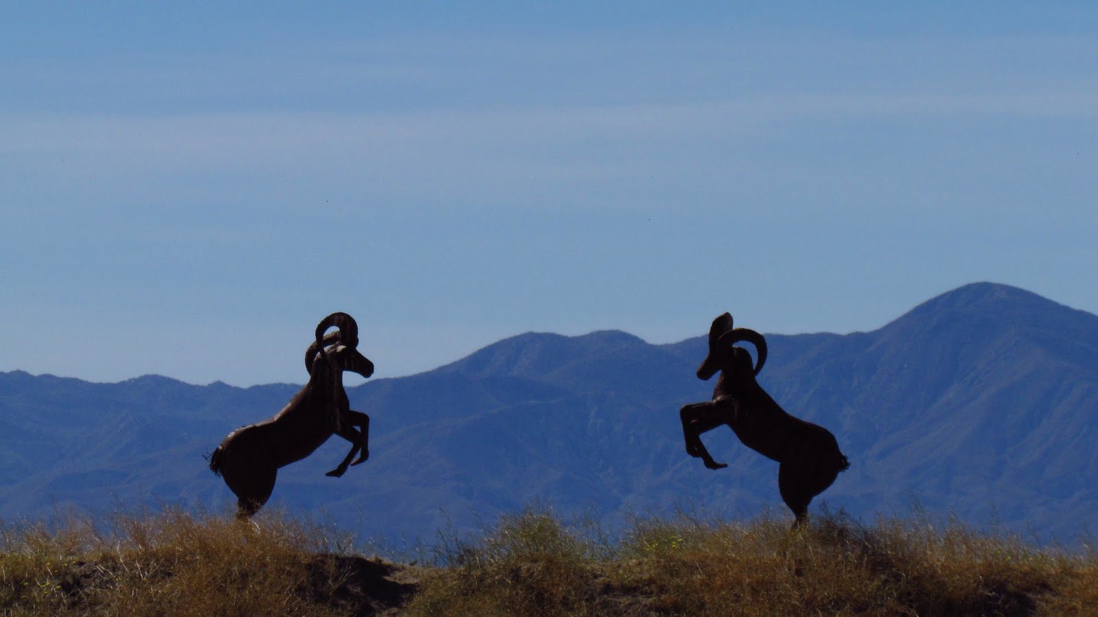
Driving around Christmas Circle in Borrego Springs, I turned on to Road/S-3 and had the excellent fortune to stumble upon the southern part of Galleta Meadows Estate owned by Denis Avery. Paying tribute to the area’s fame for fossil discoveries that demonstrate the longest continuous history of life, artist Ricardo Breceda was commissioned by Avery to weld saber tooth lions, mammoths and gomphotheriums that stand out against the big desert sky. Set back off the highway on the opposite side of the road, I saw oxidized metal sculptures of frolicking horses and a nested eagle with a 20 foot plus wing span. Elsewhere around the town, rusted tortoises appear to be lumbering along the roadside, and images of the otherwise elusive and solitary Borrego can be found in herds.
I am always inspired by the generosity of some people and Avery dishes up a double helping. Not only did he use his own dime to contract the sculptures placed visibly throughout the area, he also grants public access to them. The sign on his property indicates that with his permission visitors may hike, bike, horseback ride, and camp up to three days on the estate amidst the statues. A map of the sculptures located throughout Borrego Springs can be found at www.galletameadows.com .
Border Patrol
I rolled my Celica up to the Border Patrol guards stopping traffic along Route 111 north of El Centro. When asked where I was headed, I explained that I was here to see “their” Sea. As the guard with the German Shepherd whose head easily met mine through the open window circled the car, the one holding my license laughed and said, “Oh yeah? What do you think of our Sea so far?”
The sun was just beginning to set beyond one of the five volcanic domes located in the south western part of the Salton Sea . “Beautiful,” I replied, which earned me even more laughing. I was handed back my identification and, with the border a stone’s throw away, to stay in the vicinity of others if I would be camping and to “Be careful.” I assured them that I would be as I inched past the massive alert working dog and a white Cadillac, occupants leaning on guardrails with folded arms as officers and patrol dogs inspected the vehicle from top to bottom.
With the illegal drug and immigration still rampant along the Mexican border, the U.S. Customs and Border Protection (CBP) agents are all business. According to a CBP 2009 Fact Sheet, more than 4.75 million pounds of narcotics, (an 58 percent increase from the previous year, topping the previous five years), had been seized and more than half a million inadmissible aliens, (almost 10,000 of which were murders, rapists or child molesters), had been apprehended at the 327 U.S. air, sea and land ports of entry.
Although most Federal agencies are trimming their budgets and experiencing hiring freezes, the CBP hired 10 percent more agents in ‘09. Even the Canine Program tripled the number of work dogs along the southwest boarder and expanded their training to include currency and firearms. From the numbers of alert sentinels at that single post it would appear that a large percentage of those federally trained canines stalk the borders along southern California.
Although most Federal agencies are trimming their budgets and experiencing hiring freezes, the CBP hired 10 percent more agents in ‘09. Even the Canine Program tripled the number of work dogs along the southwest boarder and expanded their training to include currency and firearms. From the numbers of alert sentinels at that single post it would appear that a large percentage of those federally trained canines stalk the borders along southern California.
I’m not complaining.
California’s Inland Sea

The Salton Sea lies along the San Andreas Fault, which explains the volcanic cones, as well as the mud geysers and other geothermal activity prevalent throughout the area. Although its salinity is 25 percent higher than that of the ocean it is officially a lake, the largest lake in California. It is also 227 feet below sea level.
A critical part of the Pacific Flyway, it is frequented by more than 70,000 birds, including white and brown pelicans, white faced ibis, and wood storks. More than 80 percent of the existing American white pelicans use the Sea that also has the largest breeding colony of double-breasted cormorants on the West Coast.
They come for the fish, the majority of which is Tilapia, a non-native freshwater fish that also happens to be a prolific breeder. Although the Sea is as clean as Lake Tahoe, its high salinity holds less oxygen. As one of the most productive fisheries in the world, die-off cycles are natural. Due to the heat, the dead fish dehydrate quickly, thankfully.
 I pulled in to my campsite in time to catch the last rays of the sun setting over the Santa Rosa Mountain Range to the west. I would sleep well and wake at dawn to see the birds and Sea in its full glory.
 Or so I thought. Instead, I listened to the train and traffic all night long and awoke to the Blue Angels slicing across the sky above me. Used mostly for recruiting purposes, the Navy Flight Demonstration Squadron known as the Blue Angels
The noise detracted from the general mystique of the place as I crawled out from my tent at dawn. I could hear the birds in the shadows and the mist still hugging the shoreline. As the sun and fog rose though, I was stunned to see thousands of birds between me and the rose colored aptly named Santa Rosas. There were full skeletons and dehydrated carcasses of dead fish along the shores, but not as many as I had been warned there would be. And, there absolutely was no smell of decay. Just healthy sea smells. Numerous nests indented the shoreline. Life not only existed but propagated here at what so many think is a dead inland sea.
The northern section of the Sea, (and the tail end of the well irrigated Imperial Valley), is ultra agricultural with millions of acres of date palm and citrus groves, vineyards and pepper fields. The Salton Sea is lush with life.
AND, I did not see boats on the Sea. Perhaps officials wisely limit the seasons that motorized boats can be used due to marine bird breeding. All the more reason to visit the Sea in the cooler, less populated off-season.
Indian Canyons

Palm Canyon, one of three “Indian Canyons” on the Reservation in Palm Springs opened daily October – July, 8:00AM - 5:00PM, is the largest oasis of Fan Palms anywhere in the world. Behind the Trading Post, fifteen miles of hiking trails wind beneath the palm canopy set deep in a canyon along the ancient river bed where traces remain of the ancestral Cahullia Indians.
It is a stunningly beautiful, deeply peaceful place, a forest of 60 foot fan palms with occasional glimpses of majestic snow capped San Jacinto between the fronds. Picnic tables were set under the lush canopy among traditional shelters made of dried palm fronds. I had seen nothing like it in my life, so was dually impressed. Another hiker told me that there is access from the
The smaller Andreas Palm Canyon Murray Canyon
Tahquitz Canyon with its petroglyphs and seasonal 60 foot waterfall is accessible from the Tahquitz Canyon Visitor Center off West Mesquite for a $12.50 admission fee. Its steep and rocky two mile round trip trail is open October – July, 7:30AM - 5:00PM daily. Unlike the other canyons, this one is not shaded by a thick palm grove.

Leaving Indian Canyon at sunset afforded a wonderful view of the massive windmill farm just north of Route 10 set in the foothills of the Sierra Nevada ’s. Although I was planning to spend a few hours in historic Palm Springs, the post Veteran’s Day Parade traffic thwarted that plan as the downtown district was inaccessible and looked as though it would be for hours. Instead, I drove back west, towards the coast, closing a four day-650 mile trip that was well worth the time spent for the sights and memories it afforded. I’d be back to Palm Springs when things were calmer, and certainly will return to the Borrego and the Sea given their close proximity.
No comments:
Post a Comment